LanDTM 6.1 freeware

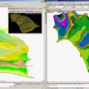
There is not any professional program on internet like this and you can get it without any effort. I think this could be a handicap because it's dificult to believe, but it's true; try it and you'll be surprised. It's not only a program to calculate a delaunay triangulation but you can input break-lines to get a real representation of the terrain. ...

Author Aplicaciones Topográficas S.L.
Released 2017-04-23
Filesize 58.80 MB
Downloads 597
OS Windows XP, Windows Vista, Windows Vista x64, Windows 7, Windows 7 x64, Windows 8, Windows 8 x64, Windows 10, Windows 10 x64
Installation Instal And Uninstall
Keywords Delaunay triangulation, Terrain Representation, CAD addon, Delaunay triangulation, Calculate, Terrain
Users' rating
(9 rating)
LanDTMCADWindows XP, Windows Vista, Windows Vista x64, Windows 7, Windows 7 x64, Windows 8, Windows 8 x64, Windows 10, Windows 10 x64
LanDTM - work time Freeware Download Notice

LanDTM Free Download - we do not host any LanDTM torrent files or links of LanDTM on rapidshare.com, depositfiles.com, megaupload.com etc. All LanDTM download links are direct LanDTM download from publisher site or their selected mirrors.

LanDTM freeware - The Latest User Reviews
LanDTM freeware - The Latest Versions History
6.1 Apr 23, 2017 New Release
6.1.6 Feb 16, 2012 New Release · New installers of the program to 32 and 64 bits platforms.
· LanDTM on BricsCAD v12.
· LanDTM on Autocad 2012.
· Separator/discriminator of points.
· Compatibility with "gsf" grid files REDNAP of Geoid ondulation.
· Elevation modification of PPuntos.
· Importation/exportationn of Points to PPuntos.
· Compatibility between formats. Trimble M3, GPS Trimble, GSI of Stonex.
6.1.5 Oct 5, 2011 New Release · You can digitalize lines and points in Google Earth and export them to the CAD. It Works in BricsCAD v11.

Most popular CAD freeware downloads

AutoCAD Mobile

5.5.0.0 freeware download

... mobile app has core design and drafting tools. Work on your CAD drawings anytime, anywhere-even offline. The ... 10 devices. Update DWG™ files in real time Access drawings with your smartphone or tablet Get ...

TNTatlas for Mac OS X

2024 B20240508 freeware download

... plays a growing part in the way we work and live. Maps, drawings, photos and related materials ... existing electronic map and database materials for those working in natural disaster relief, health and plant protection, ...

3D Home Design by Livecad

3.1 freeware download

... interface which is even more intuitive, an interior work wizard, materials manager, a smart project browser, and a catalogue with an even more complete range ...

Graph Streaming

0.7.0.12 freeware download

... experiences with graph streaming, why not start our work based on these experiences? That’s what we are ... also trying to be compatible with the available work. This Gephi Graph Streaming release is using two ...

Graph Streaming for Mac OS X

1.0.3 freeware download

... experiences with graph streaming, why not start our work based on these experiences? That’s what we are ... also trying to be compatible with the available work. This Gephi Graph Streaming release is using two ...

SoundStepper

5.4.1.304 freeware download

... processing itself, to control step motors in "real time". What SoundStepper does is to generate a data stream and send it to the sound system, ...

OpenRAVE

0.9.0 freeware download

... It provides many command line tools to work with robots and planners, and the run-time core is small enough to be used inside controllers ...

Weather Station Data Logger

5.6.0.0 freeware download

... pressure, wind and rain over varying periods of time. Data is also logged to a CSV file ... Features: This application is designed to work with the indoor console receiving multiple outdoor temperature ...

Spirograph

1.0.2.1 freeware download

... created patterns to image file · Save you work for later use · Work with multiple spirograph patterns at the same time ...

TNTatlas

2024 B20240606 freeware download

... plays a growing part in the way we work and live. Maps, drawings, photos and related materials ... existing electronic map and database materials for those working in natural disaster relief, health and plant protection, ...