MITO 2.0 freeware

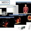
MITO toolkit makes it possible to fetch radiological information and images stored in a PACS according to the standard format DICOM, then provides the final user with basic functionalities such as 2D-3D visualization (VR, SR, MIP), image segmentation and fusion, ROI. ...

Author Giuseppe De Pietro
Released 2011-10-06
Filesize 7.20 MB
Downloads 348
OS Windows XP, Windows Vista, Windows Vista x64, Windows 7, Windows 7 x64, Windows 8, Windows 8 x64, Windows 10, Windows 10 x64
Installation Instal And Uninstall
Keywords view DICOM file, DICOM file viewer, image segmentation, display, view, viewer
Users' rating
(8 rating)
MITOCADWindows XP, Windows Vista, Windows Vista x64, Windows 7, Windows 7 x64, Windows 8, Windows 8 x64, Windows 10, Windows 10 x64
MITO - number display Freeware Download Notice

MITO Free Download - we do not host any MITO torrent files or links of MITO on rapidshare.com, depositfiles.com, megaupload.com etc. All MITO download links are direct MITO download from publisher site or their selected mirrors.

MITO freeware - The Latest User Reviews
MITO freeware - The Latest Versions History
2.0 Oct 6, 2011 New Release

Most popular CAD freeware downloads

QGIS for Mac

3.36.1 freeware download

... geotiff). QGIS supports plugins to do things like display tracks from your GPS. QGIS aims to ... daily GIS data viewing needs. QGIS supports a number of raster and vector data formats, with new ...

GstarCAD MC

3.3.1 freeware download

... offset, dimension and find text. •Set precision and display formats of coordinates, distance and angle. • Zoom ... symbols to the font’s folder in order to display all uncommon fonts. • Easily switch between 2D ...

TNTmips

20240404 freeware download

... manually add tie points in side-by-side and overlay display modes using a reference image; place control points ... devices ... Import and export an unsurpassed number of raster, geometric, and database file formats; convert ...

QGIS

3.36.1 freeware download

... geotiff). QGIS supports plugins to do things like display tracks from your GPS. QGIS aims to ... daily GIS data viewing needs. QGIS supports a number of raster and vector data formats, with new ...

QGIS for Linux

3.36.1 freeware download

... geotiff). QGIS supports plugins to do things like display tracks from your GPS. QGIS aims to ... daily GIS data viewing needs. QGIS supports a number of raster and vector data formats, with new ...

VIPER

3.49 B467 freeware download

... 25, 450-482). The software allows one to display the data as a two-dimensional plot of spectrum number (i.e. elution time) vs. mass. It can read ...

TinyCAD

3.00.04 freeware download

... use TinyCAD as a front end to a number of PCB layout program, by getting TinyCAD to ... Web & Word Creating Circuit Diagrams for display on the Web and in Word TinyCAD ...

MITO

2.0 freeware download

... "MITO - Medical Imaging TOolkit" project coagulates a number of activities aimed at defining and implementing an open-source, cross-platform software architecture for advanced Medical Imaging. ...

Weather Station Data Logger

5.6.0.0 freeware download

This Windows application will display and log weather data obtained through a USB ... includes informative discussions on many topics. The display includes most of the data available on the ...

TNTmips for Mac OS X

20240111 freeware download

... manually add tie points in side-by-side and overlay display modes using a reference image; place control points ... GPS devices. Import and export an unsurpassed number of raster, geometric, and database file formats; convert ...