Mobile Atlas Creator 2.2.1 freeware

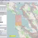
Mobile Atlas Creator is a small, simple, Java based application specially designed to help you create atlases for TrekBuddy. Basically this software will create offline atlases for GPS handhelds and cell phone applications like TrekBuddy, AndNav and other Android and WindowsCE based applications. ...

Author Fredrik Moller
Released 2021-06-02
Filesize 15.00 MB
Downloads 2252
OS Windows XP, Windows Vista, Windows Vista x64, Windows 7, Windows 7 x64, Windows 8, Windows 8 x64, Windows 10, Windows 10 x64, Linux
Installation Instal And Uninstall
Keywords create atlas, generate atlas, atlas creator, generator, generate, create
Users' rating
(28 rating)
Mobile Atlas CreatorCADWindows XP, Windows Vista, Windows Vista x64, Windows 7, Windows 7 x64, Windows 8, Windows 8 x64, Windows 10, Windows 10 x64, Linux
Mobile Atlas Creator - image map Freeware Download Notice

Mobile Atlas Creator Free Download - we do not host any Mobile Atlas Creator torrent files or links of Mobile Atlas Creator on rapidshare.com, depositfiles.com, megaupload.com etc. All Mobile Atlas Creator download links are direct Mobile Atlas Creator download from publisher site or their selected mirrors.

Mobile Atlas Creator freeware - The Latest User Reviews
Mobile Atlas Creator freeware - The Latest Versions History
2.2.1 Jun 2, 2021 New Release
2.1.3 Rev 24 Apr 14, 2020 New Release Minimum supported Java version increased to Java 8 (1.8)
"mapFile must not be null" error when creating an atlas
Save settings to settings.xml in UTF-8 format (fix for #324)
Map creation error with JPEG (Garmin Custom and others) (fix for #326)
2.1.2 Rev 24 Oct 11, 2019 New Release Minimum supported Java version increased to Java 8 (1.8)
"mapFile must not be null" error when creating an atlas
Save settings to settings.xml in UTF-8 format (fix for #324)
Map creation error with JPEG (Garmin Custom and others) (fix for #326)

Most popular CAD freeware downloads

Panoply for Mac

5.4.3 freeware download

... one plot by differencing, summing or averaging. Create map plots of trajectory data based on the CF ... Plot lon-lat data on a global or regional map using any of over 200 map projections or ...

TNTmips

20240404 freeware download

... with virtually any type of geospatial data including imagery, terrain surfaces, and map data with associated database attributes. It provides all ... without importing. Overlay your geodata on Bing Maps imagery and maps or on geodata layers published on ...

JMARS for Windows

3.1.5 freeware download

... terabyte of NASA orbiter data, and has basic image and vector processing features to conveniently compare, plot, ... and overlay them into a single, registered multilayer image. * Make topographic profiles, extract surface temperatures (day ...

JMARS

3.1.5 freeware download

... terabyte of NASA orbiter data, and has basic image and vector processing features to conveniently compare, plot, ... and overlay them into a single, registered multilayer image. * Make topographic profiles, extract surface temperatures (day ...

5 freeware award

Open Visual Trace Route

1.7.1 freeware download

... Traceroute Packet sniffer Whois 3D and 2D Map visualisation Export data to image or text Gantt view ...

MagicPlot Student for Mac OS X

2.9.3 freeware download

... scaling * Visual nonlinear curve fitting * Vector images export and copying * Automatic formula recalculation on ... only. What is disabled here? - Vector image export - Custom fit equations - Data processing ...

Mobile Atlas Creator

2.2.1 freeware download

... maps can be exported as one large PNG image with calibration MAP file for OziExplorer. As source for an offline ... OpenStreetMap, Google Maps, Yahoo Maps and other online map providers. Features: Create offline atlases for ...

Engauge Digitizer for Windows

12.0 freeware download

... This open source, digitizing software converts an image file showing a graph or map, into numbers. The image file can come from a scanner, digital camera ...

5 freeware award

Elshayal Smart

23.02 freeware download

... save GPS route and View and Rectify Raster Images gif, jpg, bmp and Edit shape files, build ... query builder, build network, find shortest path, print map, save map image, copy map image to clipboard, ...

TrueSpace

7.61 freeware download

... and render 3D content. As well as traditional images and movies, you can also make 3D content ... modeling environment, and the ability to render an image in seconds rather than hours, or an animation ...