ArcReader 10.5.0 B6491 freeware

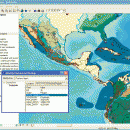
ArcReader is a free, easy-to-use desktop mapping application that allows users to ... and print maps and globes. ArcReader is a free and easy-to-use application that allows users to view and print maps that are published as Published Map Files (PMF) by the ArcGIS Publisher extension to ArcView, ArcEditor, and ArcInfo. ...

Author ESRI
Released 2017-02-02
Filesize 444.00 MB
Downloads 540
OS Windows XP, Windows Vista, Windows Vista x64, Windows 7, Windows 7 x64, Windows 8, Windows 8 x64
Installation Instal And Uninstall
Keywords view map, print PMF map, export bitmap, view, viewer, map, print
Users' rating
(18 rating)
ArcReaderCADWindows XP, Windows Vista, Windows Vista x64, Windows 7, Windows 7 x64, Windows 8, Windows 8 x64
ArcReader - export t free Freeware Download Notice

ArcReader Free Download - we do not host any ArcReader torrent files or links of ArcReader on rapidshare.com, depositfiles.com, megaupload.com etc. All ArcReader download links are direct ArcReader download from publisher site or their selected mirrors.

ArcReader freeware - The Latest User Reviews
ArcReader freeware - The Latest Versions History
10.5.0 B6491 Feb 2, 2017 New Release
10.4 B5524 Apr 10, 2016 New Release
10.3 B4332 Jan 2, 2015 New Release

Most popular CAD freeware downloads

FilterPro Desktop

3.1.0.23446 freeware download

... variations; scale passive component values; and view and export filter performance data to Excel. FilterPro ... amps. FilterPro v3.1 active filter design software is free and available for download now. FilterPro v3.1 ...

QGIS for Linux

3.36.1 freeware download

... on top of and proud to be itself Free and Open Source Software (FOSS). QGIS supports ... raster symbology (grayscale, pseudocolor and multiband RGB) · Export to Mapserver map file · Digitizing support · ...

Br3D

1.3 freeware download

Light weight, fast free 3D ViewerLight weight, fast free 3D Viewer Supports various 3D file format. Read ... by grid), Up/Down terrain, Coloring terrain(gradation), Create contour Export(LandXML 1.2), Import(LandXML 1.2) Dimension Horizontal, Vertical, Aligned, Radius, ...

Thuban for Windows

1.2.2 freeware download

... Joins # Projection Support # Printing and Vector Export # API for Add-Ons (Extensions) # Multi-Language Support: ... Why is Thuban being developed? [2001:] The FreeGIS Project provides an overview of Free Software GIS ...

Engauge Digitizer for Windows

12.0 freeware download

... as BMP, GIF, JPEG, PNG and XPM * Export support for common software packages such as Microsoft ... * Engauge Digitizer is completely open source and free courtesy of Sourceforge, Trolltech and FFTW ...

5 freeware award

QGIS

3.36.1 freeware download

... on top of and proud to be itself Free and Open Source Software (FOSS). QGIS supports ... raster symbology (grayscale, pseudocolor and multiband RGB) · Export to Mapserver map file · Digitizing support · ...

QGIS for Mac

3.36.1 freeware download

... on top of and proud to be itself Free and Open Source Software (FOSS). QGIS supports ... raster symbology (grayscale, pseudocolor and multiband RGB) · Export to Mapserver map file · Digitizing support · ...

DipTrace Free

4.3.0.0 freeware download

DipTrace is an advanced PCB design software that consists of 4 modules: PCB Layout, Schematic Capture, Component and Pattern Editors. This EDA tool is a perfect ...

Gephi

0.10.1 freeware download

... explorting in SVG or PDF. · Customizable SVG export · Save presets Clustering and hierarchical graphs: · Explore multi-level graphs with Gephi by facilitating ...

Gephi for Linux

0.10.1 freeware download

... explorting in SVG or PDF. · Customizable SVG export · Save presets Clustering and hierarchical graphs: · Explore multi-level graphs with Gephi by facilitating ...