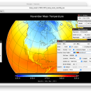
Panoply for Mac 5.4.3 freeware

Panoply for Mac is an utility that enable user to plot raster image. Depending on the data, it can draw global longitude-latitude images or pole-to-pole latitude-vertical images.Panoply is a cross-platform application which plots geo-gridded arrays from netCDF, HDF and GRIB datasets. The utility can also combine two arrays and can project the analysis using more than 100 maps. ...

Author Robert B. Schmunk
Released 2024-06-24
Filesize 36.40 MB
Downloads 755
OS Mac OS X
Installation Instal And Uninstall
Keywords plot raster image, longitude image, pole-to-pole image, raster image, rasterize, raster
Users' rating
(28 rating)
Panoply for MacCADMac OS X
Panoply for Mac - explore Freeware Download Notice

Panoply for Mac Free Download - we do not host any Panoply for Mac torrent files or links of Panoply for Mac on rapidshare.com, depositfiles.com, megaupload.com etc. All Panoply for Mac download links are direct Panoply for Mac download from publisher site or their selected mirrors.

Panoply for Mac freeware - The Latest User Reviews
Panoply for Mac freeware - The Latest Versions History
5.4.3 Jun 24, 2024 New Release
5.4.1 Jun 1, 2024 New Release
5.4.0 May 11, 2024 New Release

Most popular CAD freeware downloads

Panoply for Mac

5.4.3 freeware download

... or as a collection of invididual frame images. Explore remote THREDDS and OpenDAP catalogs and open datasets served from them. ...

ArcReader

10.5.0 B6491 freeware download

... desktop mapping application that allows users to view, explore, and print maps and globes. Anyone with ArcReader can view high-quality interactive maps authored by a ...

Thuban for Windows

1.2.2 freeware download

... viewer (GIS viewer) which features methods to visualize, explore, and analyze geographic information. Thuban is an Interactive Geographic Data Viewer with the following features: ...

Thuban for Mac OS X

1.0.1-3 freeware download

... viewer (GIS viewer) which features methods to visualize, explore, and analyze geographic information. Thuban is an Interactive Geographic Data Viewer with the following features: ...

Thuban for Linux

1.2.2 freeware download

... viewer (GIS viewer) which features methods to visualize, explore, and analyze geographic information. Thuban is an Interactive Geographic Data Viewer with the following features: ...

Energy2D

2.6 freeware download

... can use it as an inquiry tool to explore and investigate heat and mass flows in two-dimensional structures under different environmental conditions such as sunlight ...

LabQuest Emulator

1.5 freeware download

... analysis, built-in labs, periodic table, stopwatch, and more. Explore built-in curriculum including experiments such as Boyle’s law, ball toss, and titrations. If you own ...

Open Visual Trace Route

1.7.1 freeware download

Java Swing Visual Trace Route. Route is displayed in a World Wind Java cartographic component. Now you can use this accessible and easy-to-use application to ...

ParaView

5.0.1 freeware download

... using qualitative and quantitative techniques. Users can explore data in 3D or by using the application's batch processing features. ParaView was developed to ...

SDMetrics

2.5 freeware download

... easy-to-use SDMetrics graphical user interface, you can interactively explore measurement data, identify outliers, browse histograms and Kiviat charts. Command line interface: · The measurement ...