PreviSat 6.1.0.3 freeware

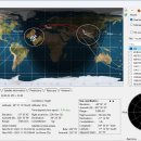
PreviSat is a satellite tracking program designed for observing purposes. PreviSat enables you to manage TLE orbital elements by updating the categories of orbital elements from the Internet and uploading data from TXT, TLE, or GZ file format. PreviSat is able to make predictions of their passes and also Iridium flares. ...

Author Astropedia
Released 2023-11-13
Filesize 23.20 MB
Downloads 1513
OS Windows XP, Windows Vista, Windows Vista x64, Windows 7, Windows 7 x64, Windows 8, Windows 8 x64, Windows 10, Windows 10 x64, Windows 11
Installation Instal And Uninstall
Keywords track satellite, satellite tracker, satellite position, track, tracker, position
Users' rating
(25 rating)
PreviSatCADWindows XP, Windows Vista, Windows Vista x64, Windows 7, Windows 7 x64, Windows 8, Windows 8 x64, Windows 10, Windows 10 x64, Windows 11
PreviSat - elevation Freeware Download Notice

PreviSat Free Download - we do not host any PreviSat torrent files or links of PreviSat on rapidshare.com, depositfiles.com, megaupload.com etc. All PreviSat download links are direct PreviSat download from publisher site or their selected mirrors.

PreviSat freeware - The Latest User Reviews
PreviSat freeware - The Latest Versions History
6.1.0.3 Nov 13, 2023 New Release
6.0.0.15 Jun 24, 2023 New Release
5.1.2.2 Dec 29, 2022 New Release

Most popular CAD freeware downloads

PreviSat

6.1.0.3 freeware download

... specifying the start and end date, location, Sun elevation, minimal elevation of the satellite, and other details. The results ...

QGIS for Linux

3.36.1 freeware download

... graduated) · Display raster data such as digital elevation models, aerial photography or landsat imagery · Change raster symbology (grayscale, pseudocolor and multiband RGB) · ...

JMARS

3.1.5 freeware download

... Take multiple datasets (thermal inertia, mineral composition, digital elevations, etc.) and overlay them into a single, registered ... on the map, making it easy to sample elevation, thermal inertia, or other surface properties in an ...

5 freeware award

JMARS for Windows

3.1.5 freeware download

... Take multiple datasets (thermal inertia, mineral composition, digital elevations, etc.) and overlay them into a single, registered ... on the map, making it easy to sample elevation, thermal inertia, or other surface properties in an ...

TNTmips

20240404 freeware download

... Surface Fitting, Contouring, and Triangulation operations produce Digital Elevation Model rasters (DEMs), contour lines, and triangulated irregular networks (TINs), respectively ... ...

QGIS

3.36.1 freeware download

... graduated) · Display raster data such as digital elevation models, aerial photography or landsat imagery · Change raster symbology (grayscale, pseudocolor and multiband RGB) · ...

QGIS for Mac

3.36.1 freeware download

... graduated) · Display raster data such as digital elevation models, aerial photography or landsat imagery · Change raster symbology (grayscale, pseudocolor and multiband RGB) · ...

PsychroCalc

1.1.0 freeware download

... SI units are fully supported. * Pressure or elevation can be entered to obtain atmospheric pressure. * A large number of unit conversions are available. ...

TNTmips for Mac OS X

20240111 freeware download

... Surface Fitting, Contouring, and Triangulation operations produce Digital Elevation Model rasters (DEMs), contour lines, and triangulated irregular networks (TINs), respectively. TNTgis software on macOS ...

GeoMapApp

3.7.1 freeware download

... The GMRT base map provides multi-resolution global elevation data upon which other data sets can be layered. GeoMapApp is developed and maintained as ...