MITO 2.0 freeware

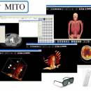
MITO toolkit makes it possible to fetch radiological information and images stored in a PACS according to the standard format DICOM, then provides the final user with basic functionalities such as 2D-3D visualization (VR, SR, MIP), image segmentation and fusion, ROI. ...

Author Giuseppe De Pietro
Released 2011-10-06
Filesize 7.20 MB
Downloads 366
OS Windows XP, Windows Vista, Windows Vista x64, Windows 7, Windows 7 x64, Windows 8, Windows 8 x64, Windows 10, Windows 10 x64
Installation Instal And Uninstall
Keywords view DICOM file, DICOM file viewer, image segmentation, display, view, viewer
Users' rating
(13 rating)
MITOCADWindows XP, Windows Vista, Windows Vista x64, Windows 7, Windows 7 x64, Windows 8, Windows 8 x64, Windows 10, Windows 10 x64
MITO - data display Freeware Download Notice

MITO Free Download - we do not host any MITO torrent files or links of MITO on rapidshare.com, depositfiles.com, megaupload.com etc. All MITO download links are direct MITO download from publisher site or their selected mirrors.

MITO freeware - The Latest User Reviews
MITO freeware - The Latest Versions History
2.0 Oct 6, 2011 New Release

Most popular CAD freeware downloads

Gwyddion for Linux

2.66 freeware download

... a modular program for SPM (scanning probe microscopy) data visualization and analysis. Primarily it is intended for ... image analysis, for instance for analysis of profilometry data (learn more about Gwyddion features). Gwyddion is ...

TNTatlas

2024 B20240606 freeware download

... you publish and distribute your maps and geospatial data — from a single geodata file to complex map layouts prepared using TNTmips. TNTatlas lets you display massive sized geodata and will directly display numerous ...

QGIS

3.36.1 freeware download

... Software (FOSS). QGIS supports vector, raster, and database formats and lets you browse and create map data on your computer. QGIS supports many common ...

Gwyddion

2.66 freeware download

... a modular program for SPM (scanning probe microscopy) data visualization and analysis. Primarily it is intended for ... image analysis, for instance for analysis of profilometry data (learn more about Gwyddion features). Gwyddion is ...

TNTmips

20240404 freeware download

... you work with virtually any type of geospatial data including imagery, terrain surfaces, and map data with associated database attributes. It provides all the tools you need ...

QGIS for Mac

3.36.1 freeware download

... Software (FOSS). QGIS supports vector, raster, and database formats and lets you browse and create map data on your computer. QGIS supports many common ...

QGIS for Linux

3.36.1 freeware download

... Software (FOSS). QGIS supports vector, raster, and database formats and lets you browse and create map data on your computer. QGIS supports many common ...

Gnuplot for Windows

5.2.7 freeware download

... scientists and students to visualize mathematical functions and data interactively, but has grown to support many non-interactive ... supports many different types of output: interactive screen display: cross-platform (Qt, wxWidgets, x11) or system-specific (MS Windows, ...

TDSL Personal Edition

1.1.1.40 freeware download

The TDSL (Tube Data Sheet Locator) Personal Edition provides information right on ... all vacuum tube types starting with 6K and display them in the filter window. Simply browse through ...

Weather Station Data Logger

5.6.0.0 freeware download

This Windows application will display and log weather data obtained through a USB connection to the Oregon ... includes informative discussions on many topics. The display includes most of the data available on the ...