Navigation:
- Freeware
- - Graphic Apps
- - CAD
- - Gephi
Gephi 0.10.1 freeware
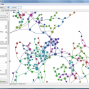
... explore and understand graphs. Like Photoshop but for data, the user interacts with the representation, manipulate the ... reveal hidden properties. The goal is to help data analysts to make hypothesis, intuitively discover patterns, isolate structure singularities or faults during data sourcing. ...
| Author | Mathieu Bastian |
| Released | 2023-01-17 |
| Filesize | 120.00 MB |
| Downloads | 1074 |
| OS | Windows XP, Windows Vista, Windows Vista x64, Windows 7, Windows 7 x64, Windows 8, Windows 8 x64, Windows 10, Windows 10 x64, Windows 11 |
| Installation | Instal And Uninstall |
| Keywords | interactive visualization, exploration platform, visualization platform, visualization, exploration, graph |
| Users' rating (33 rating) |
Gephi Free Download - we do not host any Gephi torrent files or links of Gephi on rapidshare.com, depositfiles.com, megaupload.com etc. All Gephi download links are direct Gephi download from publisher site or their selected mirrors.
| 0.10.1 | Jan 17, 2023 | New Release | Bugfixes: Problem when saving (0.10.0) Infinite loop when opening project |
| 0.9.2 | Sep 26, 2017 | New Release | New features highlight: New CSV/Spreadsheet importer migrated to Import API. More user friendly, autodetects imported columns types and data format. Integrated with the rest of file importer formats through import report. Now supports importing excel files. |
| 0.9.1 | Jan 25, 2016 | New Release | New German localization |


