DWSIM 6.6.2 freeware

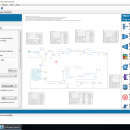
DWSIM is an easy to use, open-source chemical process simulator written in VB.NET designed with advanced thermodynamic calculations, petroleum characterization and hypothetical components utilities, accessible through a fully-featured graphical user interface. ...

Author Daniel Medeiros
Released 2021-09-07
Filesize 150.00 MB
Downloads 2289
OS Windows 7, Windows 7 x64, Windows 8, Windows 8 x64, Windows 10, Windows 10 x64
Installation Instal And Uninstall
Keywords chemical process simulation, simulate chemical process, thermodynamic calculation, simulate, simulation, analisys
Users' rating
(40 rating)
DWSIMCADWindows 7, Windows 7 x64, Windows 8, Windows 8 x64, Windows 10, Windows 10 x64
DWSIM - analyze information in Freeware Download Notice

DWSIM Free Download - we do not host any DWSIM torrent files or links of DWSIM on rapidshare.com, depositfiles.com, megaupload.com etc. All DWSIM download links are direct DWSIM download from publisher site or their selected mirrors.

DWSIM freeware - The Latest User Reviews
DWSIM freeware - The Latest Versions History
6.6.2 Sep 7, 2021 New Release
6.5.0 May 13, 2021 New Release
6.4.9 Apr 30, 2021 New Release Implemented feature request #126: Dynamics Integrator pause and resume (Classic UI)
New Separator Filler Utility (Dynamics)
Fixed issue #138: Flowsheet can't be saved
Fixed issue #137: Estimate Pipe Overall Heat Transfer Coefficient
Fixed issue #130: Stream Enthalpy not being correctly set by CAPE-OPEN Property Packages
Fixed issues with Seawater Property Package
Fixed drawing of some PFD Objects
Fixed Switch logical block behavior
Fixed active/inactive buttons not updating status in object editors (Classic UI)
Fixed Integrator results sheet formatting
Dynamics Volume-Temperature (VT) Flash fixes
Fixed distance units handling (Classic UI)
Fixed Liquid-Liquid Extraction column not working

Most popular CAD freeware downloads

TNTmips

20240404 freeware download

TNTmips software is a complete Geographic Information System (GIS) that lets you work with virtually ... of natural terrains and mathematical surfaces from 3D information. Fast and efficient Surface Fitting, Contouring, and Triangulation ...

Thuban for Windows

1.2.2 freeware download

... viewer) which features methods to visualize, explore, and analyze geographic information. Thuban is an Interactive Geographic Data Viewer ... need for a user-friendly, interactive viewer for geographic information. Thuban makes use of several Free GIS ...

Geogiga Front End

9.0 freeware download

... single shot record. You can convert data formats, analyze amplitude decay, correct trigger delay, assign geometry, mute ... in batches with the preview of layout chart Analyze amplitude decay Vertical stacking Correct trigger delay Pick ...

Weather Station Data Logger

5.6.0.0 freeware download

... the raw console data yields the following additional information: * 15-minute rate of change for temperature ... is updated once a minute with the following information: * Station and altitude-corrected pressure. * 1-minute ...

Thuban for Mac OS X

1.0.1-3 freeware download

... viewer) which features methods to visualize, explore, and analyze geographic information. Thuban is an Interactive Geographic Data Viewer ... need for a user-friendly, interactive viewer for geographic information. Thuban makes use of several Free GIS ...

Thuban for Linux

1.2.2 freeware download

... viewer) which features methods to visualize, explore, and analyze geographic information. Thuban is an Interactive Geographic Data Viewer ... need for a user-friendly, interactive viewer for geographic information. Thuban makes use of several Free GIS ...

DWSIM

6.6.2 freeware download

... that it allows them to conduct experiments and analyze data using advanced models and operations, without any ... Refluxed and Reboiled Absorbers. DWSIM also provides special information about the simulation and different means of inputting ...

UCL Depthmap

0.8.0 freeware download

... agent is able to access the visual accessibility information for its current location from the visibility graph, and this informs its choice of next destination. ...

TNTmips for Mac OS X

20240111 freeware download

TNTmips for Mac is a complete Geographic Information System (GIS) that lets you work with virtually ... of natural terrains and mathematical surfaces from 3D information. Fast and efficient Surface Fitting, Contouring, and Triangulation ...

DSI Studio

.59 freeware download

... Supported image format: · DICOM (multi-slices/mosaic) · Analyze/NIFTI · bruker 2dseq Tractography: · Stream-line tracking ... Supported file format for input ROI: text file, Analyze, NIFTI · Supported file format for output tracts: ...