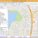
QGIS for Linux 3.36.1 freeware

QGIS supports vector, raster, and database formats and lets you browse and create map data on your computer.
QGIS supports many common spatial data formats (e.g. ESRI ShapeFile, geotiff). QGIS supports plugins to do things like display tracks from your GPS.
QGIS aims to be an easy to use GIS, providing common functions and features. The initial goal was to provide a GIS data viewer. ...

Author Gary Sherman
Released 2024-03-26
Filesize 1.00 MB
Downloads 796
OS Linux
Installation Instal And Uninstall
Keywords geographic information system, map creator, map viewer, GIS, geographic information, create, QGIS for Linux
Users' rating
(39 rating)
QGIS for LinuxCADLinux
QGIS for Linux - analysis tool Freeware Download Notice

QGIS for Linux Free Download - we do not host any QGIS for Linux torrent files or links of QGIS for Linux on rapidshare.com, depositfiles.com, megaupload.com etc. All QGIS for Linux download links are direct QGIS for Linux download from publisher site or their selected mirrors.

QGIS for Linux freeware - The Latest User Reviews
QGIS for Linux freeware - The Latest Versions History
3.36.1 Mar 26, 2024 New Release
3.36.2 Apr 25, 2024 New Release
3.36.1 Mar 26, 2024 New Release

Most popular CAD freeware downloads

QGIS for Linux

3.36.1 freeware download

... files · GRASS integration, including view, edit, and analysis · On the fly projection of vector layers ... Improved vector and attribute editing · Improved measure tools with area measuring · Attribute searching · New ...

PyRx

0.8 freeware download

... - from data preparation to job submission and analysis of the results. While it is ... easy-to-use user interface which makes it a valuable tool for Computer-Aided Drug Design. PyRx also includes ...

Cirrus Seismic Evaluation

2.5 freeware download

Cirrus Seismic Evaluation is a tool for the users that need to configure the ... to save the data or to print the analysis information displayed in the main window. ...

Seq Monk

0.24.1 freeware download

... · Creation of data groups for visualisation and analysis · Visualisation of mapped regions against an annotated ... to allow comparisons between data sets · Statistical analysis of data to find regions of interest · ...

TNTmips

20240404 freeware download

... with associated database attributes. It provides all the tools you need to view, create, edit, georeference, interpret, ... type of geospatial data. TNTmips provides professional geospatial tools in a single package at an affordable price ...

MeV

4.9.0 freeware download

MeV or Multiple Experiment Viewer is a Java tool to help you with microarray gene expression data analysis. MeV supports 5 input formats, and provides an ...

Open3DQSAR x64

2.24 freeware download

Open3DQSAR x64 is an open-source tool aimed at pharmacophore exploration by high-throughput chemometric analysis of molecular interaction fields (MIFs). Open3DQSAR can generate ... Subsequently, Open3DQSAR x64 performs fast, automated PLS chemometric analysis of MIFs allowing to quickly generate and challenge ...

Weather Station Data Logger

5.6.0.0 freeware download

... most of the data available on the console, analysis of wind and temperature data plus graphs of temperature, pressure, wind and rain over varying periods ...

JMARS for Windows

3.1.5 freeware download

... an acronym that stands for Java Mission-planning and Analysis for Remote Sensing. It is a geospatial information ... Flight Facility to provide mission planning and data-analysis tools to NASA's orbiters, instrument team members, students of ...

Qualyzer

1.2.1 freeware download

Qualyzer is a handy, easy to use application designed to support researchers conducting qualitative inquiries by helping them manage participants, transcripts, and memos. ...