SARTrack 1.019 freeware

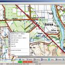
... coordinates from the keyboard or by using the data from the GPS device. The Event Log system allows the user to view the important events and to add log entries. ...

Author SARTrack Limited
Released 2021-06-01
Filesize 6.65 MB
Downloads 1489
OS Windows XP, Windows Vista, Windows Vista x64, Windows 7, Windows 7 x64, Windows 8, Windows 8 x64, Windows 10, Windows 10 x64
Installation Instal And Uninstall
Keywords radio tracker, view topographic map, add coordinate, radio, tracker, location
Users' rating
(57 rating)
SARTrackOtherWindows XP, Windows Vista, Windows Vista x64, Windows 7, Windows 7 x64, Windows 8, Windows 8 x64, Windows 10, Windows 10 x64
SARTrack - access data Freeware Download Notice

SARTrack Free Download - we do not host any SARTrack torrent files or links of SARTrack on rapidshare.com, depositfiles.com, megaupload.com etc. All SARTrack download links are direct SARTrack download from publisher site or their selected mirrors.

SARTrack freeware - The Latest User Reviews
SARTrack freeware - The Latest Versions History
1.019 Jun 1, 2021 New Release
0.9.773 Beta Jul 25, 2017 New Release SARTrack (SAR Only):
- Change: TimeLine window: Log entries marked as a "Mistake" do no longer show in the TimeLine's.
- Fix: Internal Server-Reconnect timestamp was not always up-to-date.
- Fix: Changed Database connection Timeout period, so the Server will timeout earlier than the Client. This will hopefully fix the problem of 'Duplicate Login' errors after the network connection fails.
0.9.766 Beta Oct 19, 2016 New Release SARTrack (SAR Only):
Bug fixes related to Tasking for Teams.

Most popular Other freeware downloads

GeoNetwork

4.4.4 freeware download

... viewer. It is currently used in numerous Spatial Data Infrastructure initiatives across the world. GeoNetwork has ... developed to connect spatial information communities and their data using a modern architecture, which is at the ...

Blackbird V6

1.0.85.3 freeware download

... with privacy settings that ultimately still result in data collection? Think your private information belongs to you ... and remove all Windows telemetry updates. Prevent diagnostic data, passwords, contacts, URL, SMS, handwritting, location, and P2P-update ...

PortableApps Suite

29.5.2 freeware download

... it a snap to keep your apps and data with you and safely backed up to the ... always be right at the top for instant access. You can even have the menu learn which ...

Portable Revo Uninstaller

2.4.5 freeware download

... and fast algorithm, Revo Uninstaller analyzes an application's data before uninstall and scans the computer for left-overs. ... from your drives; · You can have fast access to the most useful Windows build-in tools; · ...

tvOS for Mac OS X

13.4 B17L256 freeware download

... Atmos. And with the Siri Remote, you have access to three-axis gyro data so you can create even more engaging gaming ...

Comodo System Cleaner (64 bit)

4.0.30135.26 freeware download

... running a scan, Windows will be able to access the information it needs from the registry much ... before. System Information: · Detailed and easily accessible 'dashboard' summary of all the hardware and software ...

EasyGPS

7.13 freeware download

... information sites on the Internet, giving you one-click access to street and topo maps, aerial photos, weather ... outdoor products, you'll be able to exchange GPS data with EasyGPS and ExpertGPS users all over the ...

Network Monitor II

31.7 freeware download

... protocol. With Network Monitor II information can be accessed without installing any monitoring tools. Also gadget are ... wish the traffic counter lets you automatically save data when the gadget is shut down. Network Monitor ...

5 freeware award

Hifito

N freeware download

... an ideal tool for those who need quick access to system files or hidden directories for troubleshooting ... utilities. Whether you're a casual user looking to access hidden photos or a professional needing to tweak ...

AtlasStyler

2.0 Snapshot r201306 freeware download

... that can be used independently for any vector data. ESRI Shapefiles, OGC WFS and PostGIS datasources are supported. Automatic upload of the SLD styles ... quantiles or equal distance; additionally you have integrated access to an online symbol-database. You can create and ...